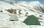
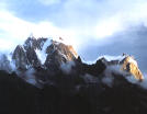
Indian
Himalayas contains some of the world's most diverse and breathtakingly
beautiful challenging impressive peaks of the Himalayan chain in the
north, high-altitude plains and remote mountain passes.
Catch the most panoramic views of the incomparable land of Indian
Himalayas. The Indian Himalayas takes you across the lovely land that it
dotted with a variety of thrill adventure destinations.
|
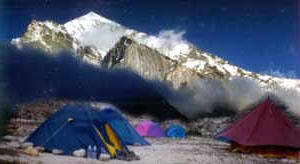
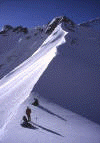
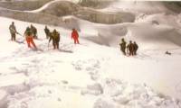
 For
High Altitude trek you need to be an experienced trekker. Going up to
5000m is demanding on the body. A good level of fitness is desirable
for your enjoyment of these treks as is a good confidence in high
altitude walking and climbing. This type of tour if for the more
adventurous, with fundamental knowledge of mountaineering. We have
managed more than 20 x 6500 mts trekking expeditions in Garhwal
Himalayas. For
High Altitude trek you need to be an experienced trekker. Going up to
5000m is demanding on the body. A good level of fitness is desirable
for your enjoyment of these treks as is a good confidence in high
altitude walking and climbing. This type of tour if for the more
adventurous, with fundamental knowledge of mountaineering. We have
managed more than 20 x 6500 mts trekking expeditions in Garhwal
Himalayas.
Angchuk, Sovat Sing have now summitted Mt.Abhigamin &
Vidhan Parwat, Jasdev and Shekhar known as well high altitude mountain guide
and we all are keen to operate with granted high altitude trekking and
mountain expedition in Garhwal Himalayas. You are requested to apply
at least one month and half months in advance, so than necessary
permissions and clearances can be obtained from the govt. authorized.
A special tariff applies to this kind of trek |
|
HIGH ALTITUDES TREK IN
UTTARANCHAL HIMALAYAS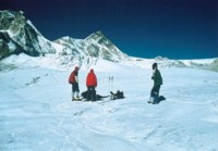
Kalandi Khal trek :
Region : Garhwal Himalayas
Duration : 14 / 16 Days.
Altitude : 5967 mt.
Place cover : Rishikesh - Badrinath - Ghastoli - Arwa glacier -
Arwatal - Kalandi.
Summary :
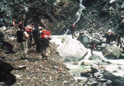
For the most adventurous trekkers, with fundamental knowledge of the
mountains,
this trek provides a rare experience . The trek takes on from
Badrinath - Ghastoli - Arwa glacier , after due acclimatization.
There is a gradual ascent of kms, thereafter, the trek negotiates at
Arwa a height of m before camping at Kalindi base (5590m.). |
Day 1 : Rishikesh - Joshimath. Drive 8/9 hrs : O/ N - H
/C
Day 2 : Joshimath - Vashudhara fall. Drive 3 hrs : trek 3 kms
Day 3 : Vasudhara Fall - Ghastoli : 13 kms trek : 3600 m.
Day 4 : Ghastoli - Arwa glacier : 9 kms trek :3780 m
Day 5 : Arwa glacier - Arwa tal : 8 kms trek : 3980m
Day 6 : Arwa tal - Kalandi Base : 7 kms trek : 5590 m
Day 7 : Kalandi Base - Kharapathar. 8 kms trek : 5500 m
Day 8 : Khara Pathar - Vasukital. 10 km trek : 4880 mt.
Day 9 : Vasuki - Nandanvan. : 22 kms trek : 4340 mt.
Day 10 : Nandanvan - Tapovan : 10 km trek : 4460 mt.
Day 11 ; Day Reserve for acclimatization and sight seeing at Tapovan.
Day 12 : Tapovan - Bhojbasa : 12 km trek : 4180 mt.
Day 13 : Bhijbasa -Gangotri. : 10 km trek : 3570 mt.
Day 14 : Gangotri - Rishikesh : 12 km trek : 3048 mt |
|
Kanari Khall / Kalla Khal trek via
Valley of flower , Bhunar khal trek :
Region : Garhwal Himalayas
Duration : 18 /20 days
Altitude : Max. 5280 m.
Area Cover : Rishikesh - Joshimath - Dronagiri - Kalla Khal -
Kanari Khal - Malarie - Gamsali - Bhunar khal -Valley Of Flowers
 Summary
: Excitemnet and challenging trip for mountain lovers, crossing huge
glaciers , boldering and moran area, covering the view of enchanting
peaks, high-altitude alps and remote mountain passes. Summary
: Excitemnet and challenging trip for mountain lovers, crossing huge
glaciers , boldering and moran area, covering the view of enchanting
peaks, high-altitude alps and remote mountain passes.
Day1 : Rishikesh - Joshimath : Drive 8/9 hrs :
O/N - C / H : 1890 m.
Day 2 : Joshimath - Day for obtaining inner line permit and other
official work.
Afternoon visit Auli Ski Resort. Overnight at the hotel or Camp.
Day 3 : Joshimath - Dronagiri village : Drive 4/5 hrs, trek 4 hrs :
2860m.
Day 4 : Dronagiri - Bagni Bamak Base camp : trek 5/6 hrs : 3560m.
Day 5 : Bagni Bamak - Bagni glacier : trek 4 /5 hrs : 3980m.
Day 6 : Bagni Bamka - Dronagiri kol : trek 6/7 hrs.
Day 7 : Dronagiri kol - Kanarikhal via garpak : trek 5/6 hrs : 4255m.
Day 8 : Garpak - Kalla khal Base : trek 4/5 hrs : 4980 m.
Day 9 : Kalla Khal base - Malarie : trek 5/6 hrs : 2890m. One Can
finish trek here & can be return back to Joshimath , further trek
leads to Bhunar Khal / Valley Of Flowers trek :
Day 10 : Malarie - Joshimath return back or further trek to Malarie -
Ghamsali - Chor hat : trek 6/7 hrs : 3575m.
Day 11 : Chorghat - Pass ; trek 5/6 hrs : 4825m.
Day 12 : Pass to - Bhunar khal : trek 6/7 hrs : 4850m.
Day 14 : Bhunar khal - Ratavan Base : trek 5/6 hrs : 4380 m.
Day 15 : Ratvan Base - Tipla kharak : trek 4/5 hrs : 3850 m.
Day 16 : Tipla kharak - Ghangaria via Valley of Flowers : trek 4/5 hrs
: 3048 m.
Day 17 : Ghangaria - Joshimath : trek 4 hrs & drive 1 hrs to Joshimath
:1890 m.
Day 18 : Joshimath - Rishikesh : Drive 8/9 hrs. |
 Bhunar
Khal : Bhunar
Khal :
Region : Garhwal Himalayas
Duration : 10 / 12 Days
Altitude : Max 5080 mt.
Place cover : Rishikesh - Joshimath - Valley Of Flower - Ratavan Peak
Base - Bhunar Khal - Ghamsali.
Summary : Most Adventures and technical trek, Bordering and Moran area
covered with Bhunar Khal Glacier. Trek cross through hazardous icy and
snowy terrain.
Day 1 : Rishikesh - Joshimath. Drive 8/9 hrs. O/N - H / C : 1890 m.
Day 2 : Joshimath - Ghangaria. Drive 1 hrs, trek 4/5 hrs : 3048 m.
Day 3 : Ghangaria - Tipla Kharak via Valley Of Flowers. Trek 6 hrs :
3850 m.
Day 4 : Tipla Kharak - Ratavan Base camp : trek 5/6 hrs : 4380m.
Day 5 : Ratavan base - Bhunar khal : trek 5/6 hrs : 4850 m.
Day 6 : Bhunar Khal - Pass (Udiyaar) : trek 4/5 hrs : 4825 m.
Day 7 : Pass - Chor ghat : trek 5/6 hrs : 3575 m.
Day 8 : Chor ghat - Ghamsali : trek 4/5 hrs : 2955 m.
Day 9 : Ghamsali - Joshimath : Drive 5/6 hrs : 1890 m.
Day 10 : Joshimath - Rishikesh.
|
 Nanda
Devi Sanctuaries trek : World Heritage site :Region : Garhwal
Himalayas Nanda
Devi Sanctuaries trek : World Heritage site :Region : Garhwal
Himalayas
Duration : 22 Days.
Altitude : Max 5155 mt.
Area Covered : Rishikesh : Joshimath : Tolma : Dharassi Pass : Lata :
Tapovan : Kuaripass : Dhakwani : Ramni : Sutol : Homkuns : Jura Gali :
Roopkund : Bedni Bughyal : Dewal.
Day 1 : Rishikesh - Joshimath : Drive 8/9 hrs. 1890m O/N H/C.
Day 2 : Joshimath - Tolma : Drive 2 hrs : trek : 4hrs. 3750 m.
Day 3 : Tolma - Dharassi Pass : Trek 5/6 hrs : 5/6 hrs : 4250 m.
Day 4 : Dharassi pass - Day reserve for sight seeing and
acclimatizing.
Day 5 : Dharassi pass - Lata kharak : trek 5/6 hrs : 3689 m.
Day 6 : Lata kharak - Tapovan via lata village (2317m) : trek 4/5 hrs,
drive 2 hrs.
Day 7 : Tapovan - Khulara - Trek 5/6 hrs : 3519m.
Day 8 : Khulara - Kuaripass via Pangarchuli peak (5150 m). 6/7 hrs
trek.
Day 9 : Kuaripass - Dhakwani : trek 5/6 hrs : 3668m.
Day 10 ; Dhakwani - Pana - trek 4/5 hrs : 2448 m.
Day 11 : Pana - Semkharak : trek 4/5 hrs : 2060 m.
Day 12 : Semkharak - Ramni ; trek 5/6 hrs ; 2200 m.
Day 13 : Ramni - Sutol : trek 5/6 hrs : 2200m.
Day 14 : Sutol - Lata khopri : trek 5/6 hrs : 2850 m.
Day 15 : Lata Khopri - Chandani ghat : trek 5/6 hrs : 3850 m.
Day 16 : Chandani ghat -Homkund : trek 5/6 hrs : 4060 m.
Day 17 : Homkund - SailSaumndra : trek 4/5 hrs : 4680 m.
Day 18 : Sail Samundra - Roopkund via Jyuri Gali (4620m). : 5/6 hrs :
4450m.
Day 19 : Roop kund - Bedni Bughyal via Bhugu Basa : trek 4/5 hrs :
4100 m.
Day 20 : Bedni - Mundoli : trek 4/5 hrs : 1970.
Day 21 ; Drive Back to Rsihikesh 8/9 hrs. |
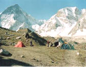
Khatling Galcier trek :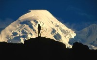
Region : Garhwal - Uttarakashi Himalayas.
Duration : 12 Days.
Altitude : Max.5020m.
Area Cover : Rishikesh : Ghuttu : Khatling : Sahsratal : Masartal :
Vasuki tal : Kedarnath : Gaurikund : Rishikesh.
Summary : The Khatlintg glacier is a lateral glacier , at the source
of river Bhilangana. Sahasratal and Masartal are on the west and east
of it. The valley of Bhilangana affords a panoramic view of snow
capped peaks and hanging glaciers, viz. Jogin group, Kirti stambh and
Meru are sublime and magnificent. At beginning the trek passes through
thick forests and beautiful lush green meadows. In the rainy season,
the meadows burst with splendid flowers. Later one have to cross two
passes above 1700 ft. and negotiates glaciers, morains and a snow
patch.
Day 1 : Rishikesh - Ghuttu : Drive 160 km : 1524m. O/N - Camp
Day 2 : Ghuttu - Reeh : trek 10 km. 2132m.
Day 3 : Reeh - Gangi : trek 12 km : 2584m.
Day 4 : Gangi - Pachari / Kharsoli : trek 14 km :2896m.
Day 5 : Kharsoli - Chowki : trek 11 km ; 3080m.
Day 6 : Chowki - Khatling glacier: trek 7 km. 3717m.
Day 7 : Khatling - Side trip Masaratal : trek 9 km :4590m.
Day 8 : Masaratal - Vasuki tal via Mayali pass : trek 15 km: 4135 m.
Day 9 : Vasuki - Kedarnath : 8 km trek ; 3584m.
Day 10 ; Kedarnath - Gauri kund : 15 km trek : 1981m.
Day 11 : Gauri kund - Rishikesh : 215 km drive : 340 m.
|
 Badrinath
- Gangotri High Altitude trek : Badrinath
- Gangotri High Altitude trek :
Region : Joshimath - Garhwal Himalayas.
Duration : 14 Days
Altitude : Max. 5967m
Area Cover : Rishikesh : Badrinath : Arwatal : Kalandi Pass : Khara
Patthar : Vasukital : Tapovan : Gangotri
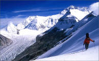
Summary : A more demanding alternative to the Kalandi Pass, with two
high passes en route to Gangotri with spectacular views.trek through
negotiates glaciers, morains and snow patch pastures to the snowcapped
peaks.
Day 1 : Rishikesh - Joshimath. Drive 8/9 hrs : O/ N - H /C
Day 2 : Joshimath - Vashudhara fall. Drive 3 hrs : trek 3 kms
Day 3 : Vasudhara Fall - Ghastoli : 13 kms trek : 3600 m.
Day 4 : Ghastoli - Arwa glacier : 9 kms trek :3780 m
Day 5 : Arwa glacier - Arwa tal : 8 kms trek : 3980m
Day 6 : Arwa tal - Kalandi Base : 7 kms trek : 5590 m
Day 7 : Kalandi Base - Kharapathar. 8 kms trek : 5500 m
Day 8 : Khara Pathar - Vasukital. 10 km trek : 4880 mt.
Day 9 : Vasuki - Nandanvan. : 22 kms trek : 4340 mt.
Day 10 : Nandanvan - Tapovan : 10 km trek : 4460 mt.
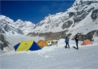
Day 11 ; Day Reserve for acclimatization and sight seeing at Tapovan.
(Base Camp - Shivling , Kedardom etc..)
Day 12 : Tapovan - Bhojbasa : 12 km trek : 4180 mt.
Day 13 : Bhijbasa -Gangotri. : 10 km trek : 3570 mt.
Day 14 : Gangotri - Rishikesh : 12 km trek : 3048 mt.
|
 Malarie
- Munsiyari High Altitude trek Malarie
- Munsiyari High Altitude trek
Region : Garhwal & Kumaon Himalayas
Duration : 12 / 14 days.
Altitude : Max.5820m.
Highest point : Topidunga.
Area covered : Rishikesh : Joshimath : Malarie : Sumanaa : Lapthal :
Chudang : Topidunga : Milam : Munsiyari.
Focus : Panorama views , snow covered peaks, moran and bolder areas ,
villages & temples.
Best Season : May / June / September / October.
Summary : One of the most difficult and challenging high altitude trek
in Garhwal & Kuamon region, almost all trails cross high passes ,
moran and bolder areas. High pitch glaciers to be cross at chudang.
Panoramic vie of snow capped peaks and enchanting glaciers and springs
with small crystal clear lakes . This trek required a special permit
from C.W.W ./ District Majestic and from Uttaranchal Government.
Day 1 : Rishikesh - Joshimath : Drive 8 /9 hrs : O /N - Camp / Hotel.
Day 2 : Joshimath - Malarie : Drive 4 /5 hrs further trek hrs to camp
side. O /N Camp.
Day 3 : Malarie - Sumana : Trek 6 hrs , after crossing a bridge we
enter to a beautiful campside Sumana. O/ N - C.
Day 4 : Sumana - Lapthal : Trek 5 /6 hrs through oak forest and
passing through a bolder area to reach Lapthal. O / N - C.
Day 5 : Lapthal - Chudang : Trek 7 / 8 hrs , after crossing a glacier
and moran ridge we camp at Chudang. O / N - C.
Day 7 : Chudang - Topidunga : Trek 7 / 8 hrs. Today is the steepest
climb to reach Topidunga pass : O / N Camp.
Day 8 : Topidunga - Dang : Trek 5/6 hrs to Dang situated in a green
grassy meadow. O/ N - Camp.
Day 9 : Dang - Milam Vvllage : Trek 5/6 hrs to a beautiful village
Milam, where we camp near by a spring. O/N Camp.
Day 10 : Milam - Burphu : Trek 4/5 hrs to Burphu . we camp after
crossing the bridge over the Gori ganga ,O/N camp.
Day 11 : Burpu - Bodgwar : Trek 5/6 hrs to Bugdyar, we camp down at
grassy ridge . O / N - Camp.
Day 11 : Bodgwar - Munsiyari : Trek 4 /5 hrs to Munsiyari,Its 2 hrs
steep climb fromBodgwar, but everything forget while 5 peaks of Punch
chulli comes on the way. We trek down to Munsiyari. O/N - Camp /
hotel.
Day 12 : Munsiyari : Rishikesh : Drive 10 / 11 hrs to Rishikesh, lunch
enroute.
We live the foothills behind and have a long drive across the pindar
river to Rishikesh. O/N - Hotel / Camp. |
|